I have attached a step by step process for creating a RT3 map from digitial terrain data and Google maps.
In writing such instructions it is easy to leave out information or to be unclear. Please let me know if the instructions can be improved.
As always, there is more than one way to do something. These instructions do not cover all means and methods to accomplish the same goal.
When wedding a Google map image to a heightmap there will never be 100% agreement. The map maker will have to make touch-ups to the map colors.
Close announcement>
New Announcement
Here be dragons! Also maniacs wildly experimenting with code.
Creating a Map from Digital Terrain Data and Google Maps
-
RulerofRails

- Dispatcher
- Posts: 310
- Joined: Sun Dec 08, 2013 1:26 am
Re: Creating a Map from Digital Terrain Data and Google Maps
Wow, 18 pages! I am really grateful for this. I am trying to make a map, but I started thinking about storyline etc. and I go looking at some other maps to see how things were done. This causes me to find new maps that sound really interesting, I end up playing them so my progress is slow. I can only hope it turns out good enough to share. 
-
delacroixp
 Re: Creating a Map from Digital Terrain Data and Google Maps
Pretty exciting stuff.
I loved the Russian map in RT3 ... look fwd to something in TM.
There was much talk of a Trans-Siberian railway from Korea and Eastern Asia to Europe (esp for double-stacked containers)
... making the trip 3-times faster than by sea (15 vs 45 days).
Railways certainly can't compete with shipping in sheer volume but it could make for a very nice niche market.
Unfortunately TM can't simulate double-stacked container transport.
Double-stacking containers is probably the main route to financial success and railroad freight resurgence ... in Europe and the rest of the world (outside of the USA) .
40t/axle railways also show great promise in attracting heavy-haul cargoes.
I guess TM has simulated the decline of railways very well
(from the heydays of the 18th century to the ease of truck and road transport).
Perhaps we could still see a rise in the financial fortunes and the increase in market share of railways in global transport.
It's all good


Pascal
I loved the Russian map in RT3 ... look fwd to something in TM.
There was much talk of a Trans-Siberian railway from Korea and Eastern Asia to Europe (esp for double-stacked containers)
... making the trip 3-times faster than by sea (15 vs 45 days).
Railways certainly can't compete with shipping in sheer volume but it could make for a very nice niche market.
Unfortunately TM can't simulate double-stacked container transport.
Double-stacking containers is probably the main route to financial success and railroad freight resurgence ... in Europe and the rest of the world (outside of the USA) .
40t/axle railways also show great promise in attracting heavy-haul cargoes.
I guess TM has simulated the decline of railways very well
(from the heydays of the 18th century to the ease of truck and road transport).
Perhaps we could still see a rise in the financial fortunes and the increase in market share of railways in global transport.
It's all good
Pascal

Re: Creating a Map from Digital Terrain Data and Google Maps
You can skin cargoes as double-stacked containers easily enough.
Gumbootz Lokomotivfabrik und Bierkeller
LMR Samson 0-4-0 - Pennsy H3 Consolidation - Custom double tank cars set
LMR Samson 0-4-0 - Pennsy H3 Consolidation - Custom double tank cars set
-
delacroixp
Re: Creating a Map from Digital Terrain Data and Google Maps
Looks mighty fine indeed and ... oops!
I meant to post in Trans-Siberian Railroad where thietavu is considering a new monster map in Siberia (along partly similar lines to his China map).
The graphic for double stacking container looks good but can you double-load a wagon to simulate a change from single to double-stacking?
I've only started TM a month ago but in Birth of a Nation (CA01) I'm using over 100 trains in the first five years.
It got me thinking that one heavy-haul train is better than 5 normal trains (which clutter up the works).
I've never run 600 trains on a massive China or USA mapped network (which should be interesting) ... but I still prefer a few monster trains to get the job done.
Naturally you don't want to sacrifice speed ... ultimately, the sheer volume of transported goods over a time period (eg 1 year) is what really matters most.
It's all good
Pascal
PS Sorry for butting in your thread.
Re: Creating a Map from Digital Terrain Data and Google Maps
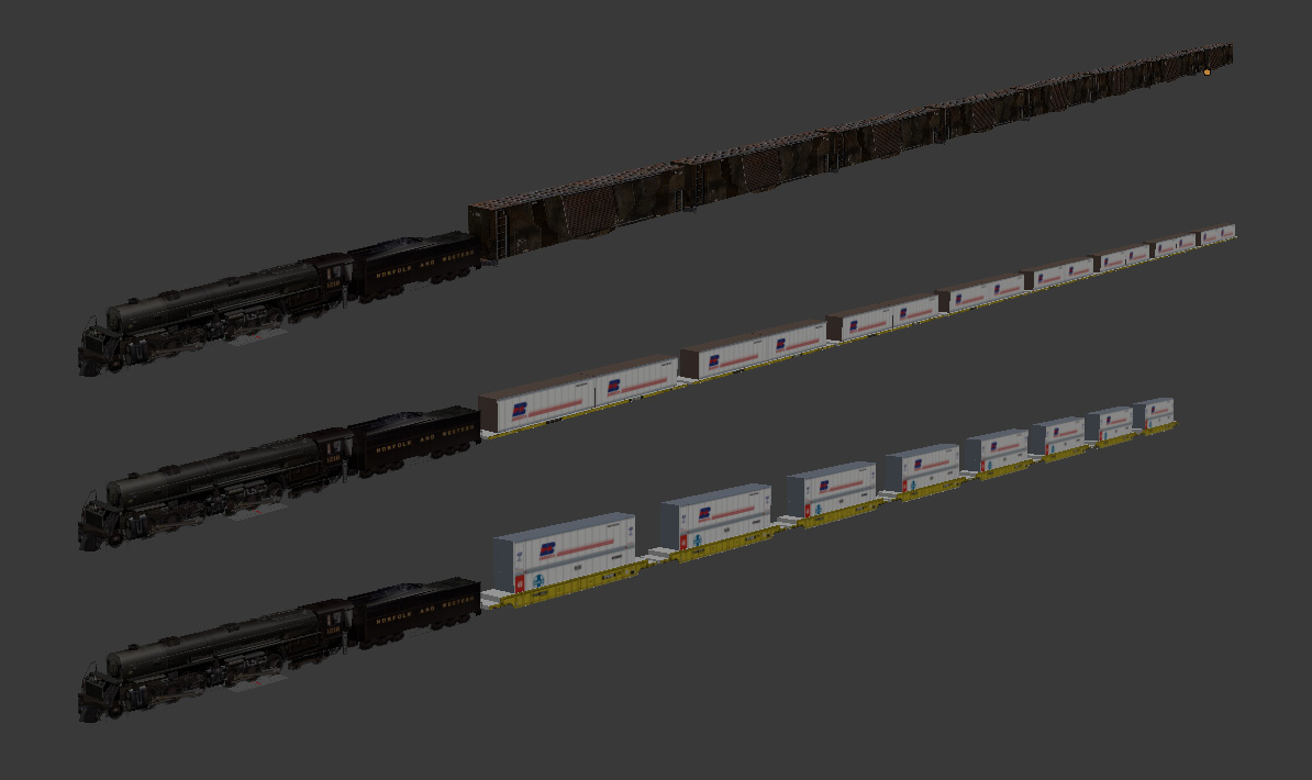
No, you can't double load things. The game is unfortunately locked to 8 loads maximum. All you can do is change the visuals. For example, I made bauxite cars that have 24 visible cars in the late era, but from the game's perspective there are still only 8 loads.
Double and triple bauxite cars
Double and triple bauxite cars
Gumbootz Lokomotivfabrik und Bierkeller
LMR Samson 0-4-0 - Pennsy H3 Consolidation - Custom double tank cars set
LMR Samson 0-4-0 - Pennsy H3 Consolidation - Custom double tank cars set
-
RulerofRails
- Dispatcher
- Posts: 310
- Joined: Sun Dec 08, 2013 1:26 am
Re: Creating a Map from Digital Terrain Data and Google Maps
delacroixp, I'm not sure how much you have read on the various threads about V1.06 and TM. Both V1.06 and TM use all the available cargo slots (IIRC, that's 51). RT3 doesn't easily allow adding new cargoes for a specific map, but it is possible.
One could envisage setting up Warehouses to pack various cargoes into double-stack containers for long distance haulage. There is a slight snag when the process goes the other way: the unpacking. Any industry that has multiple recipes that all require the same input to give varied outputs is in some ways "broken" because the game will choose the conversion that gives the industry most profit. This is good to a degree for a healthy company, but strategy dies.
A practical example is the TM Oil Refinery which will take Oil to make either Chemicals or Petroleum. In most cases, Chemicals are produced at the expense of Petroleum. However, if low Chemical prices hurt profitability for that chain too much, the refinery will automatically transition to higher Petroleum output.
As with most things, there is a work-around using cargo production modifier events. The idea is to use such an event to cut the production of all other outputs for a particular industry to allow conversion of the one specified.
Again using the TM Oil Refinery as an example, the event could fire every week and be a basic switch between Chemical and Petroleum production. One week Chemicals would be produced, the next Petroleum, in a repeating pattern. Where there are more outputs, a more advanced rotation is needed. The trick is to make sure that any such events are tied (correct use of company and territory checks) to the map in such a way that they will not affect other sources of the cargo that need to still run at normal production levels.
As far as double-loading a wagon at a certain point, this cannot be done in reality but it can be done through some price simulation. I'm sorry to tell you, if you didn't know already, that RT3 is seriously bugged when it comes to price simulation events. Any increase in price is a wide open door for the game to start losing it's marbles. But using a higher price in the first place, but that is suppressed by event until the "switch to double-stack", should be a valid workaround.
-
Cash on Wheels
Re: Creating a Map from Digital Terrain Data and Google Maps
Is 8 cars the hard coded max? How many places would I have to look? A work around for the cargo menu slider could be some thing like 0-3-6-8-12-20-24-32-48 car loads MAX instead of 0-1-2-3-4-5-6-7-8 cl MAX.Gumboots wrote:No, you can't double load things. The game is unfortunately locked to 8 loads maximum. All you can do is change the visuals. For example, I made bauxite cars that have 24 visible cars in the late era, but from the game's perspective there are still only 8 loads.
Are there any non simulator games rail games that allow double digit cars on their trains. Everything is short!
I gave those triple baux a spin. Comments about them on the triple bauxite thread.
Re: Creating a Map from Digital Terrain Data and Google Maps
Yes.Cash on Wheels wrote:Is 8 cars the hard coded max?Gumboots wrote:No, you can't double load things. The game is unfortunately locked to 8 loads maximum. All you can do is change the visuals. For example, I made bauxite cars that have 24 visible cars in the late era, but from the game's perspective there are still only 8 loads.
Dunno.How many places would I have to look?
Dunno. But yeah freight consists are too short for good visuals in RT3, which is why I've been playing around with ideas to circumvent that.Are there any non simulator games rail games that allow double digit cars on their trains. Everything is short!
Gumbootz Lokomotivfabrik und Bierkeller
LMR Samson 0-4-0 - Pennsy H3 Consolidation - Custom double tank cars set
LMR Samson 0-4-0 - Pennsy H3 Consolidation - Custom double tank cars set
-
Just Crazy Jim
Re: Creating a Map from Digital Terrain Data and Google Maps
Ok, let's say I am a bit thick. When I did exactly what the PDF said to do, my install of OSGeo4W ended up giving me a shortcut to a BAT file and no software at all. Checking the directory, I had two mostly empty folders and no executable, just a BAT file that opened the CMD window.
Seems that they changed the installation software since 2014.
I went through the process again and ended up installing a blue million things, including Python, and GRASS GIS 7.0.5, and OpenEV. I know what Python is and there is little affection between us. The other two... I've got nothin'.
Seems that they changed the installation software since 2014.
I went through the process again and ended up installing a blue million things, including Python, and GRASS GIS 7.0.5, and OpenEV. I know what Python is and there is little affection between us. The other two... I've got nothin'.